Kategorie-Archiv: Vivencias

Im Altiplano

Diese Diashow benötigt JavaScript.


Nach Cusco ging’s noch einmal hoch auf 4300m, bevor ich über den Abra La Raya sanft in die karge Schönheit des Altiplano rollte: endlose Weiten mit Bergen am fernen Horizont, gelb leuchtendes Steppengras, und für zwei Tage zeigten nur der stetig ansteigende Kilometerstand und die wandernden Schatten ein Vorankommen an – „zum Raum wird hier die Zeit“.
Es war um das kuriose Fest des Allerheiligen, abends in Sicuani plünderten Heerscharen verkleideter Kinder die Bonbon-Bestände der Kleinstadt, tagsüber passierte ich unzählige reich mit Plastikblumen und farbigem Popcorn geschmückte Gräber am Straßenrand. Einwohner luden mich zur bierseligen Feier auf die Friedhöfe, ein zweitägiger Rausch, in dem der Tod als Teil des Lebens angenommen wird, aber in einer Feier des Lebens. Man stelle sich das auf deutschen Friedhöfen vor.

Choquequirao

Diese Diashow benötigt JavaScript.


Ein letzter Anstieg und vor uns lag im warmen Licht der Nachmittagssonne die Plaza Choquequiraos, eine leuchtend grüne ebene Wiesenfläche, auf der sich stolz die Steinmauern geräumiger Häuser erhoben, die der Zeit getrotzt hatten. Vor und hinter uns fielen die Hänge steil ab ins Tal, terrassiert in hohen Stufen, die vormals dem Anbau von Getreide, Kartoffeln und Mais gedient hatten, während rechts und links der Sattel weiter anstieg zu höhergelegenen Behausungen und zu dem zentralen Versammlungsplatz, der dank seiner freien Aussicht in alle Richtungen auch zur Sternbeobachtung genutzt worden war. Für diesen Anblick waren wir zwei Tage hierher gewandert, hatten den schweren Rucksack mit der gesamten Campingausrüstung und Verpflegung für vier Tage von Cachora aus für 35km zunächst 1500m abwärts ins Tal des Río Apurimac, dann wieder 1800m aufwärts auf 3000m Höhe geschleppt, hatten der quälenden Hitze beim Aufstieg und den aggressiven Angriffen der Sandfliegen bei jedem erschöpften Stehenbleiben standgehalten, hatten unseren Durst mit gechlortem Bachwasser und teurer Cola gestillt.
Das Wunder dieser Stätte lohnte jede Mühe. Auf einem Gelände achtmal so groß wie das weitaus bekanntere Machu Picchu hatten die Inkas hier einen letzten autarken Rückzugsort im Kampf gegen die Spanier gefunden. Erst 1909 wurde die Siedlung entdeckt; noch immer sind erst 30-40% ihrer baulichen Reste archäologisch freigelegt. Monatlich finden nur 200 Abenteurer den Weg hierher (Machu Picchu: täglich bis 2500 Besucher): wir genossen die erhabene Ruhe, die über den Gipfeln lag. Umweht von ringsum vorbeiziehenden einzelnen Wolken, Wetterleuchten am Horizont, nächtigten wir einsam auf dem erhöhten Platz, bevor wir am nächsten Tag den Rückweg antraten.

Easy Riders

Diese Diashow benötigt JavaScript.


Most of the towns I passed so far on this journey looked all the similar to me, made specific only by the people I met there. Same with Huancayo: an unspectacular friendly town, where I met Aline&Cédric again, coming back from their excursion into the jungle. We continued together for the way to Ayacucho, an easy ride with a climb up to 3900m and then a gentle descent of some 250km along the valley of Río Mantaro. This river traces a narrow band of green into the surrounding desert land of eroded rocks, crooked cactuses and sandy tinted planes. We had a light time together and enjoyed ourselves – life felt free and reckless in this beautiful valley. We camped out three nights in nice camping spots along the way. For the first night we pitched our tents next to a natural pool after an adventurous river crossing in a small cable car. The courteous dueño took us on an evening walk up the steep water formed rocks to some old and rotten mills where we balanced on a 5m high water sewer. It was a refreshing rest, before we crossed the desert valley all in dust the next days.
The traffic on the only radial road into Ayacucho was heavy and gave us a rough ride. We rented a shower there and left the same night in bus to Abancay.
Since my camera broke down, I owe some of the pictures above to Aline&Cédric: many thanks!

Copyright GoogleMaps

Sky is the limit

Diese Diashow benötigt JavaScript.


Between these two mining cities lies the large plain of Lago Junín, the highest-located lake in the world. It is endless space stretched out to the mountains on the far horizon, yellow dust under a blue sky, white and blue gleaming of the water surface surrounded by browsing alpacas and chirping birds.
I crossed the void to Huallay with its famous bosque de piedras, animal-shaped rocks, and the next day back on a dirt road via Pari to Ondores, a lonesome village at the lake. The longly threatening tempest caught me there, but just at the right moment, I got a ride to Junín: Tito and Shannon, an american volunteer for the local ecologic lake organization, loaded my bike on their four by four truck and drove me the 20km alongside the lake banks, beautifully covered with pink flamingos. It was still so cold that my hostal’s landlord supplied hot-water bottles for the night.

Minenstädte

Diese Diashow benötigt JavaScript.


Von der quirligen Stadt Huánuco auf 1900m führte mich die nächste Etappe wieder hoch in die Berge, hoch auf 4300m. Cerro de Pasco hat mich empfangen, wie es sich für die höchste Stadt der Welt gebührt: mit eisigen 5ºC und kräftigem Hagel, der innerhalb von Minuten einen weißen Teppich auf die karge Steinlandschaft legte. Diese Wetterlage unterstrich passend den Charme der Trostlosigkeit: die grauen Häuserfronten, den schwarzen Teich und das 200m tiefe Loch der hochproduktiven Blei- und Zinkmine direkt in der Mitte der Stadt. Bei meinem Abendspaziergang zur Mine hatte ich eine unliebsame Begegnung mit zwei verwahrlosten Jugendlichen und eine angenehmere mit drei reizenden Polizistinnen, mit denen ich während eines einstündigen Stromausfalls einen Becher ponche trank.
Die Minenerzeugnisse von Kupfer, Blei und Zink der gesamten andinen Umgebung werden in La Oroya weiterverarbeitet, im Sinn der Superlative eine der verschmutztesten Städte der Welt (Blacksmith Report 2007): die Bleiwerte im Blut von Kindern unter 10 Jahren übersteigen das WHO-Limit um das Dreifache, die Wasserversorgung der 33.000 Bewohner ist hochkontaminiert und die Luft enthält 85mal mehr Arsen, 41mal mehr Kadmium und 13mal mehr Blei als generelle Grenzwerte für gesund erachten. Zu meiner Überraschung sah ich das dem freundlich bunten Stadtbild rund um die Schmelzerei nicht an, nur die stark erodierten umgebenden Berge leuchten toxisch schwefelgelb, zuckergußweiß und magentarot.
Ich folgte weiter dem Tal des Río Mantaro, doch keines der spärlichen Dörfer bot Unterkunft. Zum Zelten war es zu regnerisch; es wurde ein langer Ritt durch Nacht und Regen, bis ich nach 140 Tageskilometern in Jauja eine Bleibe fand.
Bis Huancayo war es dann nicht mehr weit. Seit Huánuco bin ich 403km und 4100 Höhenmeter geradelt.

Copyright GoogleMaps

Into the wild

Diese Diashow benötigt JavaScript.


Einmal mehr durchquerte ich die Cordillera Blanca, diesmal den Südteil von Cátac bis Huallanca, diesmal mit dem Fahrrad und vollem Gepäck. Für zwei Tage kein Dorf, nur die vereinzelten Strohhütten scheuer Bergbauern, nur die grobe Schotterstraße, die auf 4800m anstieg, nur die Berge, am Horizont, dann unter meinen Reifen. Die wunderbare Landschaft belohnte reichlich alle Mühen, die Atemlosigkeit auf dem Pass, die morgendliche Kälte, die beißenden Hagelschauer am Nachmittag. In ihrer Farbigkeit, ihren Aussichten, ihrer Stimmung gehört diese Etappe zu den Höhepunkten meiner Reise, zu den unauslöschlichen Erinnerungen, die mich für immer begleiten werden.
Die beiden verbleibenden Tagesetappen bis Huánuco waren vergleichsweise einfaches Radfahren, auf Asphalt durch das Pampa-Tal des jungen Río Marañón, zwei Anstiege auf knapp 4000m, dann eine 60km lange Abfahrt um 2100 Höhenmeter, die allerdings durch den strömenden eiskalten Dauerregen beschwerlich wurde. Huánuco gilt als die Stadt del mejor clima del mundo, tatsächlich setzte der Regen 10km vor Ankunft aus. Nach der Einsamkeit der vergangenen Tage pulsierendes Stadtleben, westlich gekleidete Menschen, Verkehrschaos und tortilla de verduras. Der concierge meines Hostels in der unmittelbaren Nachbarschaft unzähliger Automatenkasinos und hübscher Damen trug bei meinem Anblick als Berufsbezeichnung wortlos aventurero in sein Gästebuch ein.

Seit Caraz bin ich, den Tagesausflug zur Laguna Churup eingeschlossen, 405km und 6020 Höhenmeter (aufwärts) geradelt.

Copyright googleMaps

Days off in Huaraz

Diese Diashow benötigt JavaScript.


I cycled the short distance to the andinista town Huaraz, but I did not feel strong enough these last days to continue. I rather opted for a few quiet days of recovery, reading, writing and waiting for a new bicycle chain ordered from Lima (the 10 gear cassette seems not the best choice for these remote regions).
Today, I undertook a beautiful excursion to the Laguna Churup in the Huascarán park, climbing up to 3800m by bike and then hiking for 1,5 hours further up to 4500m where this crystal-clear lake is stretched out on the feet of the clouded mountain Churup. I admired the sunset, but had then a hard time descending on the roughly gravelled road: out of the dark, angry dogs attacked me several times and I had to firmly defend myself shouting and throwing rocks. I was glad to reach my lovely hostel at about 8p.m.
On the St.Cruz trek a week ago, I had a look in the detailed headcount statistics of the guardian at Huascarán park. The most common nationalities are Israelis, French and Germans (with only about 4 Peruvian visitors each month). The hostal housed the very same proportion. Talking to the Israeli guests, they explained to me that it is very popular to schedule a year of southamerican adventure after their obligatory three (for women: two) years of military service.
Tomorrow I’ll set off again, now come the real mountains. The only true mystery, my friend, is the road, the road ahead.

Huascarán National Park

Diese Diashow benötigt JavaScript.


The Huascarán park contains 16 peaks higher than 6000m of the cordillera blanca which is the world’s highest mountain range out of Asia. I could not resist the temptation to traverse it on the splendid St. Cruz Trek, which for four days (and three camping nights) crosses its northern part and offers beautiful views on the main summits.
The colectivo to the starting point Cashapampa was fully occupied: 3 persons in the front row next to the driver, 4 persons in the middle row and one older lady among the luggage in the trunk. Carrying the heavy bagpack stuffed with camping equipment, warm clothing and food for 4-5 days, walking becomes another category: move slow and carefully watch every step, since a twisted ankle may become a severe problem in this remote wilderness. Luckily, the route climbs moderately for two days up to the mountain pass Punta Unión at 4750m and descends with some ups and downs to Vaquería at 3700m. In the first night, at a nice camping spot near a river, I met the colombian mountaineer José and the swiss couple Aline & Cédric, both cyclists as well, and we continued the trek together. The second day led us through a nice sand plane up to a camp site at the foot of the Alpamayo, dubbed „the most beautiful mountain of the world“. It was indeed an impressive view even from the southern, less glacially side, but as soon as the sun disappeared behind the ridge, I slipped into the sleeping bag, out of the cold. The next day was a long hike of about 10 hours over the highest point of the trek (unfortunably a very clouded view) and down to the sweet valley of the Río Huaripampa. During the night, I was caught out of the sudden by a heavy diarrea which made the normally easy 5hours-walk to Vaqueriá the next day a hard tour. With two pills of immodium (many thanks Aline!), I survived the 4 hours ride in the again very cramped colectivo back to Caraz: the road was rough but beautifully passed the icy mountain Huascarán (6768m) and the Lagunas Llanganuco. When arriving Caraz, I felt like Messner must have felt when coming from Mt.Everest: back to the pleasance of civilisation, a shower, a good meal and the satisfaction of a great experience.
In the meanwhile, Germany had made its choice between an uninspired chancellor and a fen fire on the ego trip.

Copyright by mcsa.org.za

Cañon del Pato

Diese Diashow benötigt JavaScript.


These last days had completely spoilt a set of brake pads. It was good to have new ones for the long descent from 3200m (Pallasca) down to 500m (Chuquicara). In spite of the strong head wind, the temperature was at 40°C and the air was so dry that a road worker, asking me for un aguacito emptied my one-liter bottle at once. (I got another one handed over from a passing car later).
Water was a severe problem in all villages of this region: they generally shut down the public supply during the night and -in case of shortage- even during day time. You realize the immense value of water opening the tap and nothing happens…
I’ll never forget the beautiful scenery of this desert valley: the rocks were shining in black, brown, red, yellow, rich in minerals.
Arriving with the darkness at the few huts of Chuquicara, I met the world cyclist Henrik, cycling already for 3 years. We spent a superb evening having four beers and an interesting conversation about our experiences with the cultural differences here, and were friendly invited for the night on two mattresses on the earth floor nearby. He headed for the coast the next morning, while I went for the famous Cañon del Pato, a collection of tunnels digged into hard rocks and steep hillsides.
Leaving Huallanca, I met the google street car – they got a nice picture. I often wondered that, especially in Peru, there are still white spots: google maps and OSM miss a lot of villages and the few paper maps you may find (only foreign publishers) are full of mistakes, confounding town names, indicating wrong distances or altitudes or marking crossroads as villages. It is kind of comforting that even nowadays in our controlled world, there is still free space for discovery…
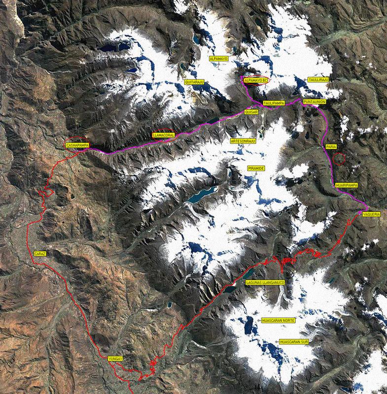
I arrived the calm and lovely mountaineer town Caraz the next evening.
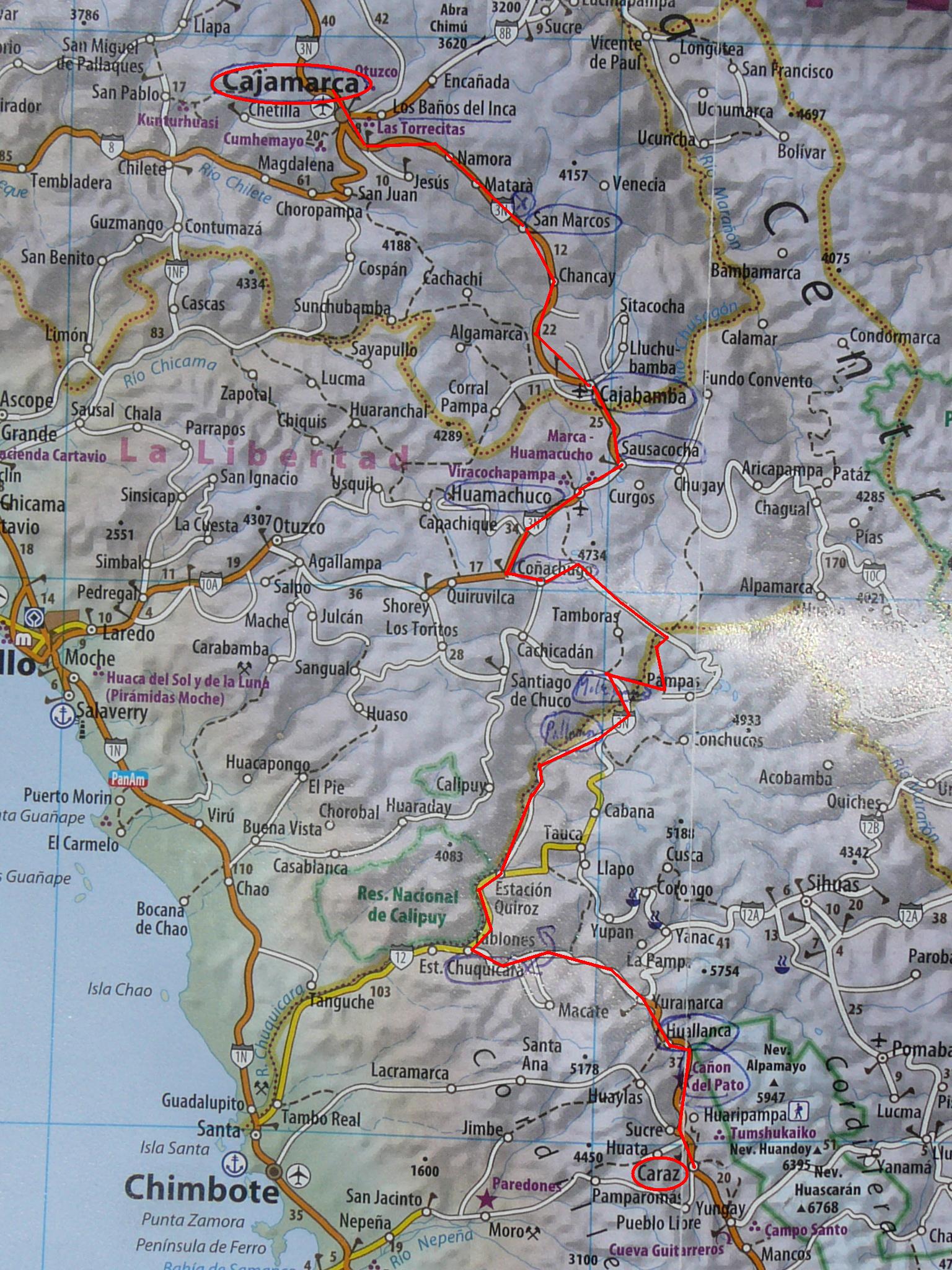
Since Cajamarca I’ce cycled for 495km, climbing 8400 altitude meters.

Pallasca

Diese Diashow benötigt JavaScript.


When I came back from breakfast the other morning, I found the hostel closed – the owners had left. Neighbours indicated to me that el dueño was school teacher, so I went to the local college: it was his day off. But, knocking on the classrooms, I could finally get grasp of his son who had the key…
It was a long descent via Mollepata and a long climb in 22 curves on the other hill side up to Pallasca. But after this week on tough gravel and sand, I was just glad to be back on tarmac again. During the climb, I had a friendly conversation with a campesina: she told me that in winter time, all these dry and yellow hills are green!
In the nice mountain village of Pallasca, I took a día de descanso and enjoyed a hike to a mountain pass and the cima Chonta above the village.