Kategorie-Archiv: Vivencias

Über Grenzen

Diese Diashow benötigt JavaScript.


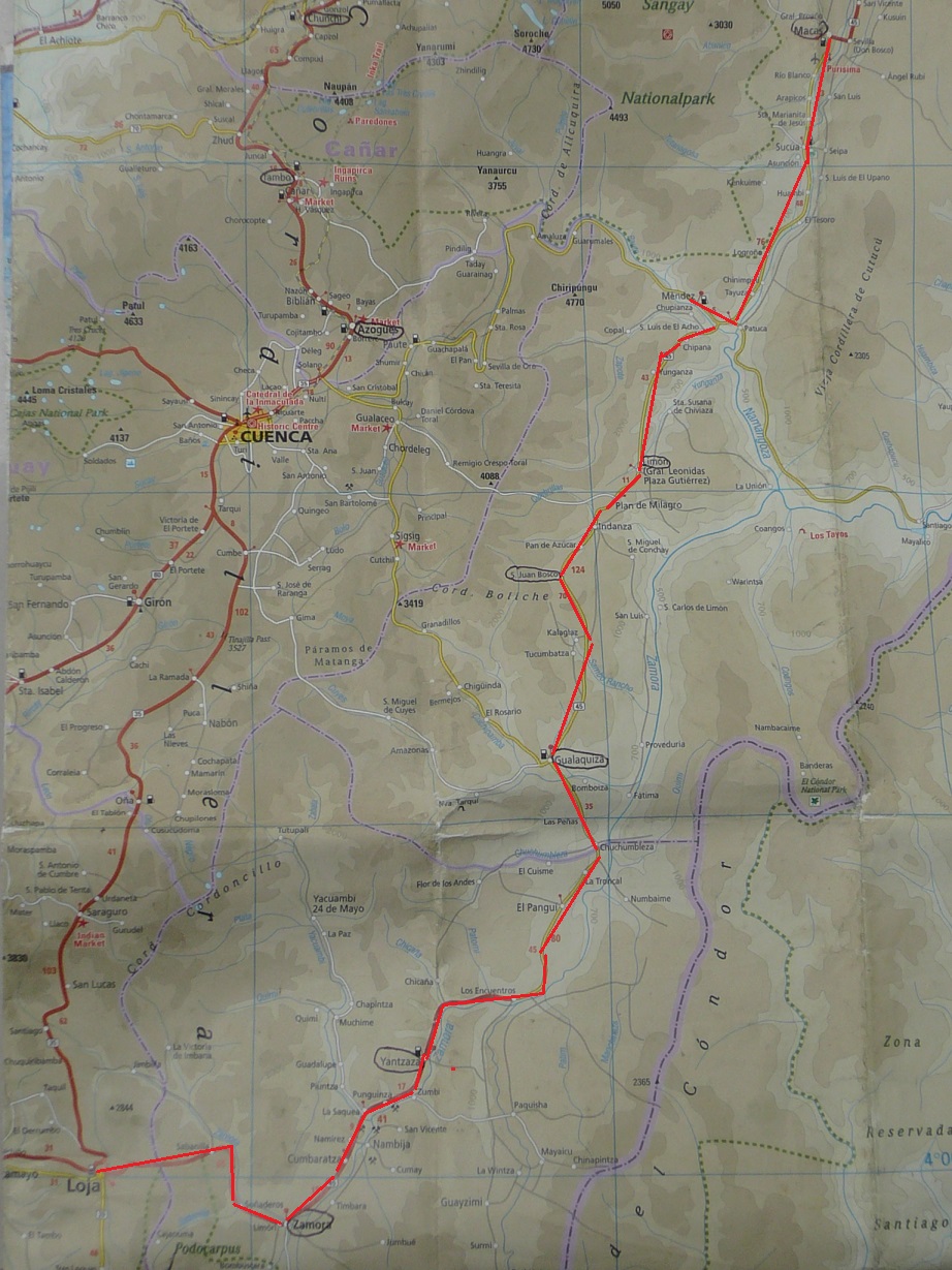
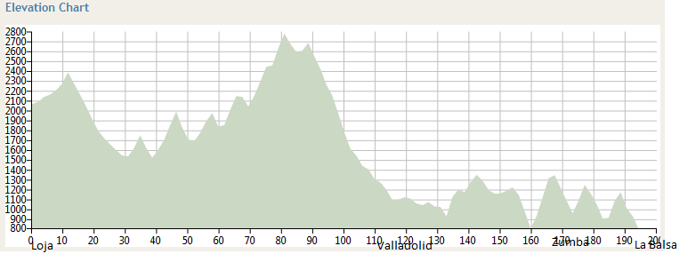
Vilcabamba liegt zwar auf gemäßigten 1500m, ist aber ringsum von hohen Bergen umgeben. Nach einem ausgedehnten Abschied konnte ich den langen Aufstieg zur Wasserscheide des Kontinents erst am nächsten Tag von Yangana im Nachbartal aus angehen: vorbei an sandigen Bergabbrüchen, deren sanfte güne Bewaldung bis zum Pass auf 2800m stetig in den kargeren Moosbewuchs der Paramó-Region überging. Immer wieder begegneten mir die selben freundlich grüßenden Truckfahrer, mal schwer mit Schutt beladen, mal unbeladen; allerdings waren die Straßenarbeiten auf der anderen Seite der Wasserscheide noch nicht sehr weit vorgedrungen: schon auf halber Abfahrt, noch vor Valladolid, harte Schotter-, dann Sandpiste, immer wieder mit meterlangen Schlammpools durchsetzt. In den Abendstunden erreichte ich Palanda, wo ich auf dem zentralen Platz das Fahrrad unter den neugierigen Augen der gemütlich vor ihren Häusern sitzenden Bewohner von seiner zentimeterdicken Erdschicht befreite. Angesichts der Etappe am folgenden Tag war das eine provisorische, vergebliche Unternehmung: Schlammbäder wechselten sich ab mit erfrischenden Flußquerungen, während sich der Pfad mit einigen kräftigen Ausschlägen nach oben und unten um die 1100 Höhenmeter durch dichtes Grün schlängelte. Am Wegrand aus Brettern gezimmerte Behausungen, deren lachende Bewohner sich gerne auf kurze, freundliche Gespräche über den Straßenbau, ihre Lebensumstände und ihre politischen Erwartungen einließen. Ich stand gerade barfuß in der Mitte einer Bachquerung, als ein vorbeifahrender Lkw anhielt, mich grüßte und mir von seinen acht glücklichen Jahren im deutschen Transportwesen erzählte. Es machte mich froh, mit seinen begeisterten Augen auf mein Heimatland blicken zu können (auch wenn meine Füße anschließend Eisklötzen glichen).
20km vor meinem Tagesziel, Zumba, brach die Nacht herein, am überdachten Rand eines abgelegenen Fußballplatzes schlug ich mein Zelt auf, als auf der dunklen Straße, angekündigt durch Hundegebell im Dorf, die Schattengestalt eines Radfahrers langsam vorüberzog. Rufend („somos ciclistas, yo tambien, a donde vas, quedate conmigo„) rannte ich der gespenstischen Erscheinung für etwa hundert Meter hinterher, die aber stumm und unbeirrt ihren Weg fortsetzte. Ich saß vor dem Zelt und blickte in die Stille der Nacht, als sich die Gegend plötzlich belebte: unvermittelt umgab mich eine Heerschar von Kindern, Flutlicht-Scheinwerfer gingen an und unter tausend staunenden Fragen war ich eingeladen zu einer nächtlichen Fußballpartie. Herzlich war der Abschied und herzlich das Wiedersehen mit Wilmer und Paul am nächsten Morgen.
In Zumba traf ich Ron aus Colorado, das nächtliche Phantom, gemeinsam radelten wir das steinige Auf und Ab durch das einsame Land bis zum kleinen Grenzübergang bei La Balsa. Mit den Stempeln in unseren Pässen waren wir in Peru und glücklich auch wieder auf Asphalt.
Seit Loja: 204km und 4860 Höhenmeter aufwärts.

Courtesy of bikeroutetoaster.com

On sacred ground

Diese Diashow benötigt JavaScript.


After a few calm days in Loja, Andy decided to go back to Quito for the time of his recovery. After a first failing try together at the bus terminal the evening before, we said goodbye (yes, it rained), he pushing one-handed his bike, while I pulled out of town in the late afternoon heading South. This time we knew that we would not see each other on this continent again, that we both had separate journeys now.
I enjoyed a long descent over Malacatos to Vilcabamba, which is the Quechua-word for ‚the valley of the sacred tree‘. Its Mediterranean climate and its reputation for the longevity of its residents make it an attraction for extranjeros and nowadays, there probably live more americans and europeans here than natives. The village is nicely surrounded by red hills which reach up into the paramó-region of the Podocarpus national park. Its rich mineral soil provides a perfect filter system for the local water enriching it as well with manganese whose oxidation capacity is dealt as one reason for the statistical longevity. I pitched my tent at the camping site of the Rumi Wilco Nature Reserve, a private national park on a green and specious hillside, and enjoyed some days of intense recreation: reading about the local geology and plants, hiking with German and Enric to the near Mandango mountain, walking to the Podocarpus park, and becoming acquainted with other travellers: with German students on a reforestation project, with a Dutchman hiking through the whole cordillera of the Andes (and I thought I was crazy enough!), with two couples travelling the world for years (when travelling becomes a life-style…), with girls of the Basque country, with German and Enric and there project to bring literature to the children of remote Andean villages.
Many of the local names for hills and plants, specifically in this area but in the whole country, carry poetic spiritual meanings originating from the Quechua language (e.g. Mandango ‚the sleeping deity‘) and the culture of shamanism and healing illnesses by natural means is very common. While I can be enraptured by the view of a landscape and fascinated by the complex interdependent system of nature, my western mind still has some caveat against the direct consumption of plants. For better or worse, we somehow trust Novartis more than the Cinchona (the national tree of Ecuador) in our garden. This might be a habit to challenge.

Weites Land: Through the Oriente from Macas to Loja

Diese Diashow benötigt JavaScript.


Leaving Macas, the landscape had changed: the common picture we have in mind when we think of jungle and Amazonas. The road meandered through the valley of Río Upano, past wooden shacks hidden in Banana plantations, a freshly bleeding dog dead on the tarmac, and in the afternoon a black wall of rain which catched me up 5km to Mendez. In the following days, until Loja, I should understand why the rainforest has its name. There is rain coming like a black wall and chasing you, there is malicious rain dropping suddenly out of the blue sky, there is sneaky rain, starting as mere increased humidity and when you notice it you are already wet, there is dumb rain being there when you start, going down like a curtain of strings until the evening, and there is intermittent rain catching you whenever you just wrapped up the raingear in the depths of the luggage. I had all of these in changing orders.
After the bus excursion from Mendez to Cuenca (see there), I was eager to ride the bike again. It became a long day. The way oscillated up and down around 1000m altitude in a pure greenhouse („Gewächshaus“) climate. Sweating at 36º humid Celsius, but with nice views into the valley of Yungaza, I reached Limón for lunch and had an informative discussion with a kiosk owner about the mines nearby: time ago, his parents fished for gold in the local river, now great parts of the region are licensed to big chinese mining companies. For them, the government has tarmaced the sand tracks five years ago (and still large constructions!). I should see one of those mines after Zamora (see pictures above). With a long climb to Plan de Milagro and a steady descent, I accumulated 2270 height meters upwards, my new day record after Pasto, and reached the little town S.Juan Bosco in dawn.
The next day involved again two stiff climbs to 1840m altitude each. On the 10km earth road after the dreary street village Tucumbatza in the middle of the forest, around a turn, two dogs attacked me. Of course, this happened before, and my normal procedure for barking and snatching dogs is to shout at them and to sprinkle them with water. The next step of escalation is to stop and get off the bike. This needs some overcoming but normally breaks the chasing pattern. Here it didn’t. I faced the approaching beasts baring their teeths. I kept shouting at them, barking myself, and took stones up from the ground which I threw at them from 1,5m distance. All instincts were concentrated in those moments of fight, eye in eye with the primeval nature. Since then, I always carry some stones at hand.
The next morning in Gualaquiza, I faced a more modern problem: the days in the small villages without any cash points had consumed up my spare money reserves and I was not able to pay the bill for the night nor buy any food or water with the 35cts in my pocket. The amicable host family understood my delicate situation, and equipped with a few bananas and two liters of drinkable water, I hit the straight road to Yantzaza which I arrived in one ride in the afternoon. Imagine my fright when the only larger cash point there failed due to a blackout! The problem was settled to my great relief later that day…
In continued the next morning the short and flat way crossing the river Yucuambi to Zamora, where I spent one day in the national park Podocarpus (see there) before tackling the last stiff climb up to Loja at 2300m altitude. After an extended goodbye, I only left at 12.30 (in a rain of the dumb sort). The climb took no end. At 6.30 p.m., I was still struggling in the rain and mist at 2980m. What a miracle when out of night and darkness the lights of Loja appeared!
After these 565km with 10.476 height meters climbing since Riobamba, I met there again Andy with the german cyclist Armin. Andy, just before arriving Loja on the Panamericana, had a severe road accident and injured badly his shoulder. I admire him for his composure in this situation and wish him a fast recovery!


Map of Reise Know-How Ecuador (1:650 000)

Into the jungle: the National Park Podocarpus

Diese Diashow benötigt JavaScript.


Just before arriving Zamora, I felt, for the first time on this journey, a sharp muscle cramp in my right thigh. I decided to take a day off hiking in the near national park Podocarpus, named after a type of conifers. It is known mainly for the 560 different species of birds which have been registered there. I have seen only a few of them, nicely coloured, black with a yellow tail e.g. At the park entrance I had met a friendly family, together we went to the nice waterfall of Río Bombuscaro, in whose crystal-clear water they took a bath – fully dressed, even with shoes on!
In the afternoon, I followed for about one hour a path right through the brush to an elevated natural mirador and enjoyed the cloudy view over the surrounding, densely wooded hills.

Landslide on the way to the park

Cuenca, die Perle des Südens

Diese Diashow benötigt JavaScript.


Von Mendez aus, eine Tagesetappe von Macas entfernt, unternahm ich eine fünfstündige Busfahrt nach Cuenca: um diese mit knapp einer halben Million Einwohner nach Guayaquil und Quito drittgrößte Stadt Ecuadors zu sehen, und auch, um mich mit einem Gaskocher unabhängiger von der hiesigen carnivorischen Küche zu machen, die mich bereits fünf krankheitsbedingte Ruhetage und fünf Gewichtskilo gekostet hat. Die Busfahrt war allerdings eine riskante Angelegenheit: mit schmelzend süßer Cumbia-Musik holperten wir auf der grob geschotterten Bergstraße rasant dahin, in engen Kurven langsamere Lastwagen überholend -immer freundlich grüßend, mit wilden Schlenkern Schlaglöchern ausweichend, zentimeternah vorbei an steilen Abgründen.
Die Zeit verging also kurzweilig und wohlbehalten erreichte der vollbesetzte Bus Cuenca, wo ich mich für einige Stunden ganz dem Zauber der Stadt überließ: den narrow streets of copplestone, dem Charme des Blumenmarkts, der Pracht der Kathedrale, der stolz zurückhaltenden Kolonialarchitektur der Andorra-weiß getünchten Altstadt-Häuser, dem erfrischenden Grün entlang des Río Tomebamba. Nach langer Suche in den einschlägigen Geschäften fand ich schließlich auch den Gaskocher.

Reise in ein Land vor unserer Zeit

Diese Diashow benötigt JavaScript.


Nach einem weiteren Ruhe-Tag in der unaufgeregten Stadt Riobamba, „dem Sultan der Anden“, umgeben von den weißen Gipfeln des Chimborazo, des Altar und des Sangay, fand ich frühmorgens problemlos die ruhige Straße zu den Lagunas de Atillo auf 3530m, die dann den Parque National Sangay nach Macas auf 1000m durchquert. Diese Straße ist zu klein, um im Google-Universum gelistet zu sein. Sie führte mich aufwärts durch farbreich terrassierte Hügel in „ein Land vor unserer Zeit“: Frauen in rot und pink leuchtenden Gewändern Milchkübel tragend, Männer mit schweren Hacken furchenziehend. Die Idylle der grünen Wiesen wich kargeren Hängen in gedeckten Brauntönen, die sich im Dämmerlicht im Grau dichter Wolkenbänke verloren. Es regnete, das Thermometer fiel auf 7ºC, aber in gleichem Maß stieg die Freundlichkeit der Menschen am Wegesrand: für Momente blitzte sie wieder auf, die Offenheit, die Neugierde und Fröhlichkeit, die mir in Kolumbien immer wieder begegnet waren – „woher kommst Du? warum reist Du allein? suchst Du eine Freundin? schenkst Du mir Dein Rad?“ Ich nächtigte in einer der an den Hang geduckten einfachen Hütten mit den weit herabgezogenen Schilfdächern, die ich mir mit einem herzlichen Straßenarbeiter teilte.
Durchfroren nach einer etwas zugigen Nacht und in immer noch feuchten Schuhen passierte ich gegen 8Uhr am nächsten Morgen die Lagunen, ruhige wolkenverhangene Bergseen (mit A.Stifter: „Augen der Natur“), bevor ich auf der Ostseite der Sierra in sattes Grün hinabtauchte: dichter, moosbekleideter Baumbestand löste sich verwunschen aus den Nebelschwaden, durchsetzt mit Farnen und rauschenden Wasserfällen, ab 1200m dann auch mit einzelnen Palmen. Die letzten 25km bis 5km vor Macas waren allerdings Knochenarbeit: in langgezogener Gegensteigung auf einer grob geschotterten, von Erdrutschen stark malträtierten, schlaglochgespickten Straße. Hundertschaften von Bauarbeitern arbeiteten abschnittsweise an der Sicherung der erodierten Hangseiten, an der Kanalisation von Bachübergängen, an der Planierung und Asphaltierung des Kiesbetts, Dutzende von Lastwägen transportierten Steingut. Mir war nicht bewußt, was für ein Aufwand und eine ungeheure Leistung der Straßenbau ist; in Deutschland liegt die infrastrukturelle Erschließung ja auch schon zwei Generationen zurück. Hier wird zurecht stolz plakatiert: „tenemos carreteras de primera. tenemos patria.“
In starkem Regen erreichte ich schließlich nach 162km und 2442 Höhenmetern aufwärts (seit Riobamba) am späten Nachmittag das unspektakuläre Macas, wo ich den Abend damit zubrachte, das Fahrrad und die Ausrüstung wieder in einen fahrbereiten Zustand zu versetzen.

Courtesy of OSM http://www.opencyclemap.org/.

No Man’s Land

Diese Diashow benötigt JavaScript.


Wir passierten die Polizeisperre der noch immer geschlossenen Verbindungsstraße nach Riobamba anstandslos: „Tienen una reserva en Penipe? De acuerdo. Pero cuidado!“ Stetig ansteigend, verlor sich die asphaltierte Fahrspur allerdings bald unter den bröckelnden Erdmassen, die die Schlammlawinen des zurückliegenden Ausbruchs hinterlassen hatten. Eine trostlose, unwirtliche Mondlandschaft, die der starke Regen nicht unbedingt gangbarer machte. Hinter einem der Moränenhügel trafen wir das von unserem Anblick völlig überraschte Fernsehteam des Nationalsenders Tele TC, das ein kurzes Interview mit den beiden radelnden gringos in die Abendnachrichten brachte. Einen gehörigen Schreck jagte uns das plötzlich einsetzende nahe Donnern ein, das uns dann, mal lauter, mal ferner, den gesamten Nachmittag über begleitete. Wir hatten am Morgen die unbedenklich lautenden Berichte der lokalen geophysikalischen Beobachtungsstation abgerufen; wie wir aber später erfuhren, hatte sich die vulkanische Aktivität im Tagesverlauf zur ‚orangenen Warnstufe‘ mit pyroklastischen Strömen verstärkt. Uns molestierte davon momentan nur der dichte Nebel und der in den Augen beißende Niederschlag feiner Aschenpartikel, die sich flockenartig auf unseren Jacken und Taschen sammelten. Wie in Trance folgten wir weiter dem Taleinschnitt, zur Linken das Donnern des Tungurahua, in der Mitte des Tals den durch den Regen der vergangenen Tage stark angeschwollenen Río Chambo, auf der rechten Seite steile Geröllhänge, die polternd Gesteinsbrocken hinabsandten. Inmitten dieser rumorenden Urgewalten vereinzelte Wohnhäuser, alle verlassen. Es war ein Anblick wie nach dem zeitlichen und räumlichen Ende der Welt, erhebend und gewaltig, es war ein Erlebnis, das einen das Leben intensiver spüren läßt.
In der Dunkelheit erreichten wir Penipe.
Siehe auch den Bericht von Andy for an english version of this adventure.


Stream Crossing: bitte auf Play klicken!


Falling rocks: Bitte auf Play klicken!

Map of road and pyroclastic flow around the Tungurahua (explosion of 14/07-13) (Source)

Baños

Diese Diashow benötigt JavaScript.


In Latacunga haben wir uns für eine Exkursion nach Baños, den in jeder Hinsicht ‚westlichsten‘ Vorposten des ecuatorianischen Regenwalds entschieden, für uns ein Umweg von 60km und 2000 Höhenmetern. Aber was heißt ‚Umweg‘ auf einer Reise wie der unseren…
Baños, auf 1800m ü.N.N. am Fuß des aktiven Vulkans Tungurahua gelegen, ist eine ausgesprochen touristische Kleinstadt (18.000 native Einwohner), mit einer Vielzahl von Hostels, Touroperatoren und Pizzerien.
Um dem Rummel zu entrinnen, mieteten wir zwei Fahrräder für die urige Strecke zum Paílón del Diablo, einem gigantischen Wasserfall des Río Verde: nach zwei Kilometern zerlegte sich die Hinterradachse meines betagten Rads.
Trotz dieser durchwachsenen Erfahrung mit der Verläßlichkeit des hiesigen Materials, konnte ich später am Nachmittag, nach dem Rückmarsch nun auf einem neuen Bike, der Versuchung nicht widerstehen, ein Canopy am Weg auszuprobieren, ein 1km langes Drahtseil, das man kopfüber mit bis zu 90km/h in eine Schlucht hinabgleitet.
Unseren Aufbruch am nächsten Morgen verhinderte der neuerliche Ausbruch des Tungurahua: die Verbindungsstraße über Penipe nach Riobamba war vom Lavafluß betroffen und infolgedessen gesperrt. Leider konnten wir aufgrund der dichten Bewölkung bis auf einige Staubwirbel auch später am Abend bei einem Ausflug auf den höhergelegenen Aussichtspunkt de la Virgen nichts von den heißen Vorgängen sehen.
Zuletzt im Jahr 1999 war die gesamte Stadt wegen der starken seismischen Aktivität für mehr als 5 Monate evakuiert worden.
In einem freundlichen Gespräch mit einer ortsansässigen Caña-Verkäuferin bestätigte sich zumindest der erste Teil des häufig strapazierten Zitats von Alex Humboldt:
„Die Ecuadorianer sind seltsame und einmalige Wesen: sie schlafen ganz ruhig mitten unter knisternden Vulkanen, sie leben arm inmitten von unermesslichen Reichtümern und sie freuen sich über traurige Musik.“

Cotopaxi

Diese Diashow benötigt JavaScript.


Cycling the part of the Panamericana between Quito and Ambato that Alex Humboldt once called the „alley of the volcanoes“: nowadays a large highway with at times four lanes in each direction. Black clouds of exhaust from the left, glass splinter on your track, barking dogs from the right and steadily subiendo. But the landscape is indeed marvellous: numerous volcanoes at both sides, the Pasochoa, Illiniza and Rumiñahui.
Reaching in the evening of the second day at last the entry to the Cotopaxi National Park, we sneaked under a fence of barbed wire, which Andi had secured with his carabiner „to comply with German safety standards“, and pitched hiddenly our tents in thick forest at 3500m, the highest I have ever camped. Next day we climbed up to a seemingly abandoned train station in the middle of nowhere and tried to cross over to the base of Cotopaxi whose white cap we saw from far. But the road was broken and after several hours of hard work pushing our bikes over braided paths, we returned to the Panamericana, filled up our pasta supplies and chose another park entrance. Again, we found a nice quiet spot for camping hidden in the forest and enjoyed with the sunset a rich pasta meal from Andi’s stove. After drying our tents from the heavy rain at night, we worked our way up on a perfectly tarmaced, later gravelled road through the beautiful landscape at the mountain base to a campsite at 3800m. As luck would have it, a whole battalion of soldiers had a training session the whole night through which kept me awake for long hours, listening to the wind and pondering confused thoughts.
I’ve set up my alarm clock at 4.30 a.m. to ascend the near volcano Rumiñahui, but when I sticked my head out of the tent, it was all rain and mist and I preferred to stay in the warm sleeping bag for a few hours more. After a pasta breakfast with Andi, I cycled some kilometers up the hill to the lagoon Limpiopungo. The lagoon was not that special, but the landscape was just breathtaking: a large plane at about 3900m altitude in all shades of brown, browsing horses in front of the steep rise to the gleaming white crown of Cotopaxi (5943m).
After striking the tents in a quite strong storm, we enjoyed the long ride of about 25km down to Lasso (lunchtime) and continued on the Panamericana to Latacunga.
With one night of interruption at a pension in Tambillo, we now have camped out for 12 nights. My Nordisk tent suits me perfectly: extremely lightweight, it offers just enough space for me and the luggage and stood uncompromisingly the heavy rain and strong wind at 3800m. Crawling into the tent and closing the zip behind me, I feel on my own, sheltered and comfortably, listening to the sounds of the night, the murmuring wind, the gentle dropping rain. La vida se siente tan libre en estos momentos.

For a Fistful of Dollars

Tonight, I was robbed by two muchachos in the streets of Tumbaco. It was a short encounter with the brute directness of imposition, the rapid crossing of foreign life lines, the intrusion of characters in my life not chosen to meet deliberately.
I was out for dinner with Lili: we had delicious Tortillas de Papa and humitas, bags of corn, in a traditional restaurant, later two beers and the time passed rapidly with kind chatting about life and future. At about eleven p.m. we walked down a lonely street near the central parque to fetch a cab when behind a passing car two youngsters in hoodie jackets crossed the road to our side. Lili, with an accurate intuition instantly suspicious, began to run while I, just not believing that something like that could ever happen, continued steadily. The first guy stopped me while the other approached me from behind. After a short struggle and a little conversation (que quieren?, que quieren?), they got away with a five dollar note of my wallet. A cheap but important lesson: when in doubt, better run.